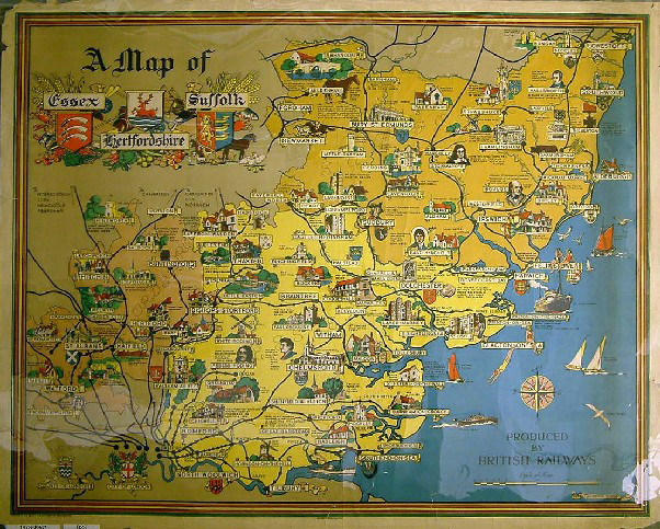
A Map of Essex, Suffolk and Hertfordshire
- Made:
- circa 1953 in London
- publisher:
- British Railways, Eastern Region
- artist:
- Lawrence Stone
- maker:
- British Railways and
- George Philip & Son


![]() This image is released under a CC BY-NC-SA 4.0 Licence
This image is released under a CC BY-NC-SA 4.0 Licence
Buy this image as a print
BuyLicense this image for commercial use at Science and Society Picture Library
License![]() This image is released under a CC BY-NC-SA 4.0 Licence
This image is released under a CC BY-NC-SA 4.0 Licence
Buy this image as a print
BuyLicense this image for commercial use at Science and Society Picture Library
License
Science Museum Group Collection
© The Board of Trustees of the Science Museum
Science Museum Group Collection
© The Board of Trustees of the Science Museum
Poster, British Railways (Eastern Region), A Map of Essex, Suffolk and Hertfordshire, by Lawrence Stone, about 1953. Coloured lithograph depicting the three counties, illustrated with buildings and historic figures associated with the places featured. In the sea are bathers, seabirds and shipping, with a compass. The title, at top left, features the county coats of arms. At bottom right are the words "Produced by British Railways" with the artist's name written on a scroll. Text in the bottom margin reads "Published for the Railway Executive (Eastern Region)(PP1130); Printed in Great Britain; George Philip & Son., Ltd." Format quad royal.
Details
- Category:
- Railway Posters, Notices & Handbills
- Object Number:
- 1978-8947
- Materials:
- paper
- type:
- poster