Solartron Video Map Generator for Air Traffic Control PPI Radar displays, c. 1960
- Made:
- 1960-1970
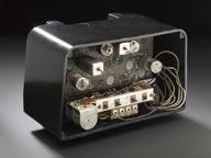
Solartron Video Map Generator for showing local terrain details on Air Traffic Control PPI Radar displays, c. 1960. Uses flying-spot scanner techniques (used in television to produce video signals from films and slides) to superimpose on a PPI radar picture details of local terrain, an important feature of air traffic control.
Solartron introduced this system in the late 1950s and such map generators were in use up until at least the late 1980s, when they began to be superseded by digital image-storing systems linked to computer graphic techniques for generating the information to be displayed along with the video information with the radar system.
Details
- Category:
- Radio Communication
- Object Number:
- 1994-472
- type:
- radar equipment
- credit:
- National Air Traffic Services (Stroud)