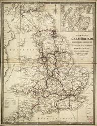
Coloured map. Philips' Railway Map of the British Isles, with large scale inset maps of the principal industrial centres (Midlands Manufacturing Districts, Newcastle & Middlesbrough Districts, London District, Lancashire & Yorkshire Manufacturing Districts and Edinburgh & Glasgow District). (c1916). Published by George Philip & Son Ltd. Backed on linen. 785 x 1012mm.
Details
- Category:
- Railway Maps & Plans
- Object Number:
- 1997-7151
- Measurements:
-
: 785 x 1012 mm
- type:
- coloured map
- credit:
- Peterson, H.