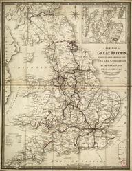
Map of the Railways, showing the various stations with the hills, rivers, canals and principal roads, of England and Wales ...
- Made:
- 1840
.Colour-engraved map. Map of the Railways, showing the various stations with the hills, rivers, canals and principal roads, of England and Wales, also exhibiting most of the places whose situation has been ascertained by the Stations and Intersections of the Trigonometrical Survey / Compiled by A. Arrowsmith, Hydrographer to His Majesty. 1840 (1845 printing). 4 sheets.
Details
- Category:
- Railway Maps & Plans
- Object Number:
- 2000-1485
- Measurements:
-
overall (each): 935 x 745 mm
- type:
- map
- credit:
- Unknown source