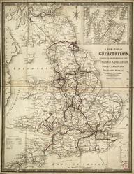
Geological & Mineralogical Map of England and Wales, with parts of Scotland, Ireland & France
- Made:
- 1838
Coloured map, fully titled "Geological & Mineralogical Map of England and Wales, with parts of Scotland, Ireland & France, Showing also the Inland Navigation by means of Rivers and Canals, with their elevation in feet above the sea, together with the Rail Roads and Principal Roads." Made by J. A. Knipe of London, dated 1 June 1838. With a leather slip case.
Details
- Category:
- Railway Maps & Plans
- Object Number:
- 2004-7202
- Materials:
- paper (fibre product) and linen (textile)
- type:
- map