Smith's Map of England & Wales showing all the Railways
- Made:
- 1849 in Greater London
- maker:
- C. Smith & Son
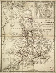
Smith's Map of England & Wales showing all the Railways, Roads, Rivers & Canals, 1849. Printed for C. Smith & Son, mapsellers, 172 The Strand, London. In a slipcase.
Details
- Category:
- Railway Maps & Plans
- Object Number:
- 2006-7497
- Materials:
- paper (fibre product) and linen (textile)
- Measurements:
-
overall: 205 mm x 150 mm x , ,
- type:
- map
- credit:
- I. van der Meulen van de Pol