Military map from First Gulf War, 1990-1995
- Made:
- 1990-1995 in United States

Military Map from First Gulf War, published by the Defense Mapping Agency, United States, 1990-1995.
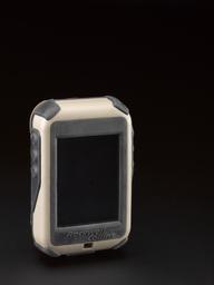
With very few contour lines, this map shows the extremely flat landscape that troops needed to navigate during the First Gulf War. Changeable terrain military maps were often out of date or inaccurate. During the First Gulf War troops began to use GPS receivers, for the first time, using the accurate location information to plot their position on the featureless maps.
Details
- Category:
- Navigation
- Object Number:
- 2014-74
- Materials:
- paper (fibre product)
- Measurements:
-
overall: 575 mm x 740 mm .37 kg
- type:
- map
- credit:
- Donated by Hugh Boscawen