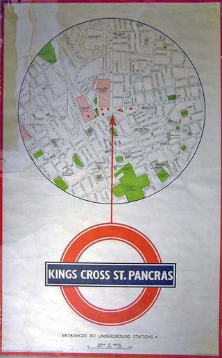
Poster Map. Kings Cross St Pancras. Street plan of area around St Pancras and Kings Cross Stations, London, showing entrances to underground station. June 1939. Ref: 39/5466/GX/100 (based upon the Ordnance Survey map). Printed by Stanford's Geographical Establishment, London. Format: double royal. Dimensions: 40 x 25 inches, 1016 x 635mm. King's Cross St Pancras map 1939
Map of the world (Mercator Projection) by Edward Stanford, London marked to show eclipse tracks illustrating the Saros period between 1927 to 2164. Map of the world marked to show eclipse tracks during the Saros period, 1927-2164 1927
Diagram, the astral cipher emblems of the signs of the zodiac. Diagram, the astral cipher emblems of the signs of the zodiac
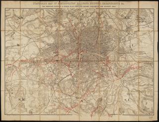
The smaller railway amalgamation map of England and Wales shewing the districts served by each railway system reduced from the larger map by R. Price Williams, Esqe. C.E. [Publisher Edward Stanford, Charing Cross, London. 1 col. litho sheet folded within boards. Board bears title label 'Railway Amalgamation of England'. Scale 1" : c.11 1/4m.] The smaller railway amalgamation map of England and Wales shewing the districts served by each railway system ... 1874
Stanford's New Map of Metropolitan Railways and Miscellaneous Improvements, sanctioned in 1866; also the Railways in Operation, and those Sanctioned before 1866, as far as Croydon, Hounslow, and Barnet; with a list of the plans [printed map] / Edward Stanford (publisher, 6 Charing Cross, London). 1866 Sept. 1 sheet folded within boards. Scale 2" : 1m. Post sessional edition] Stanford's New Map of Metropolitan Railways and Miscellaneous Improvements, sanctioned in 1866 .... 1866
Map. London & Ten Miles Around. A New Map of Railways & Miscellaneous Improvements sanctioned in 1865, also the Railways in Operation and those sanctioned before 1865. With (inset) an enlargement of the Eastern Part of the Metropolis. Published by Edward Stanford, 6 Charing Cross; Vacher & Sons, 29 Parliament Street; Letts & Co, Royal Exchange; London. 10 August 1865. Printed by Stanford's Geographical Establishment, London. Backed on linen and folded with covers (one missing). 893 x 734 mm (flat). 137 x 197 mm (folded). London & ten miles around 1865