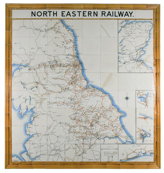
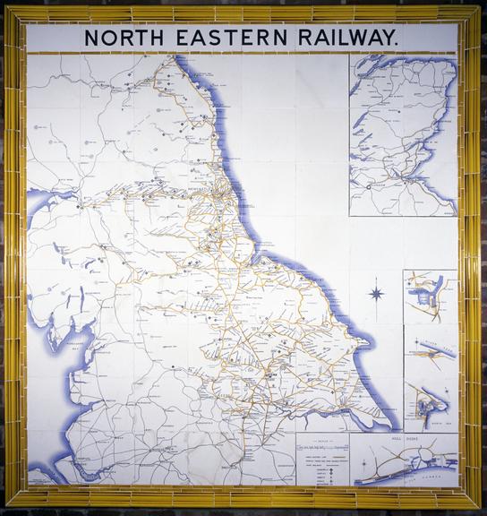
Ceramic tile map of North Eastern Railway
- Made:
- circa 1900 in Shropshire
- maker:
- Craven Dunnill


![]() This image is released under a CC BY-NC-SA 4.0
Licence
This image is released under a CC BY-NC-SA 4.0
Licence
Buy this image as a print
BuyLicense this image for commercial use at Science and Society Picture Library
License![]() This image is released under a CC BY-NC-SA 4.0
Licence
This image is released under a CC BY-NC-SA 4.0
Licence
Buy this image as a print
BuyLicense this image for commercial use at Science and Society Picture Library
LicenseMap, ceramic tiles, showing the North Eastern Railway network
Science Museum Group
© The Board of Trustees of the Science Museum
Science Museum Group Collection
© The Board of Trustees of the Science Museum
Map, ceramic tiles, showing the North Eastern Railway network, manufactured by Craven, Dunnill & Co Ltd, about 1900. Comprises 64 white glazed ceramic tiles 203mm square with a border of 48 moulded capping tiles. Eight half tiles at the top spell out the words "North Eastern Railway". The tile at bottom left reads "Produced by Craven, Dunnill & Co., Ltd., Jackfield". The map depicts northern England, from the Dee estuary in the west to Spurn Head in the east, north to Berwick-upon-Tweed. It includes the line from Beverley to North Frodingham, representing the North Holderness Light Railway, which was never built. There are inset maps of Hull docks, Hartlepool, Middlesbrough and Tyne Dock, and a map depicting eastern Scotland, from the border near Berwick to Inverness and the Moray Firth.