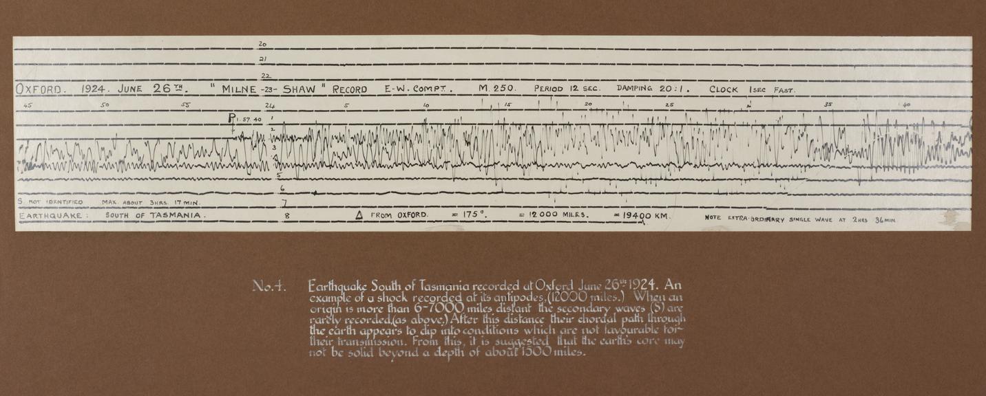
Enlarged seismogram of earthquake south of Tasmania, 26 June 1924.
- maker:
- John Johnson Shaw
![]() This image is released under a CC BY-NC-SA 4.0
Licence
This image is released under a CC BY-NC-SA 4.0
Licence
License this image for commercial use at Science and Society Picture Library
License
Science Museum Group Collection
© The Board of Trustees of the Science Museum
Photoenlargement of a seismogram of an earthquake with an epicentre south of Tasmania, recorded on a Milne-Shaw seismograph at Oxford, England, 26 June 1924. Mounted on display board with caption: ‘No.4. Earthquake South of Tasmania recorded at Oxford June 26th 1924. An example of a shock recorded at its antipodes (12000 miles). When an origin is more than 6-7000 miles distant the secondary waves (S) are rarely recorded (as above). After this distance their chordal path through the earth appears to dip into conditions which are not favourable for their transmission. From this, it is suggested that the earth’s core may not be solid beyond a depth of about 1500 miles.’
Milne-Shaw seismographs were amongst several designs of mechanical, pendulum-based seismograph available in the early 1900s that could detect the vibrations from distant earthquakes. They were modified versions of a device originally designed by seismologist John Milne around 1895, but incorporating a system of electromagnetic damping (to prevent the horizontal pendulum acquiring its own swing) and providing records of greater magnification. These modifications were designed by John Johnson Shaw, a seismology enthusiast who built the instruments himself for despatch to observatories and stations around the world.
Analysing the arrival times different types of earthquake waves enabled geophysicists to locate earthquake epicentres, and also to infer the interior structure of the earth. When this record was captured and its label written, interpretations of seismic data were still contested. For example, it was not until 1936 that the Danish seismologist Inge Lehmann used seismological analysis to propose earth’s core consisted of a solid centre and molten outer, which is the model scientists agree upon today.
Seismologists now identify the earthquake recorded in this seismogram to have occurred on the subantarctic Macquarie Island, and calculate its magnitude as 7.5 on the Richter scale.
Details
- Category:
- Geophysics
- Object Number:
- 1926-663
- Materials:
- paper (fibre product)
- Measurements:
-
overall: 310 mm x 710 mm x 2 mm,
- type:
- enlargements
- credit:
- Shaw, John Johnson