Bartholomew's Railway Map of the British Isles
- Made:
- 1939
![]() This image is released under a CC BY-NC-SA 4.0
Licence
This image is released under a CC BY-NC-SA 4.0
Licence
License this image for commercial use at Science and Society Picture Library
License
Science Museum Group
© The Board of Trustees of the Science Museum
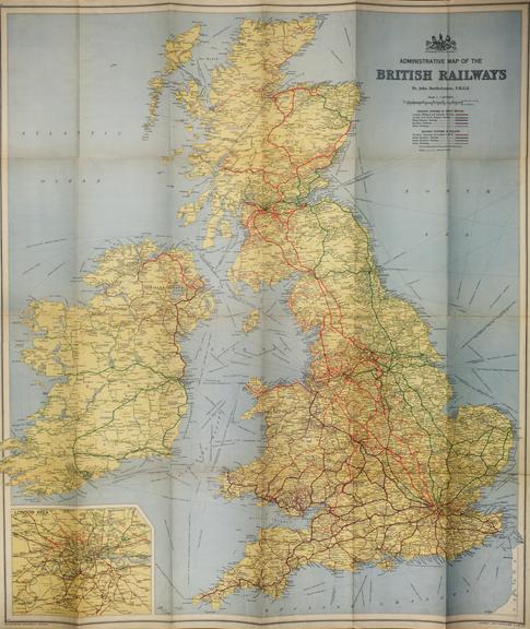
Bartholomew's Railway Map of the British Isles, c. 1939.
This map is made by John Bartholomew and Sons Limited, a company famous for its work in mapmaking and the use of layered colouring to produce clear and vibrant maps. The map depicts the most important railways of the time in bright colours, as well as shipping routes and canals across the entirety of the British Isles. It indicates where two railway companies had working arrangements on the same section of track by using interchanged coloured dashes. Important locations within the British Isles are marked on the map in plain bold text and by placing this text within small white boxes.
The publisher was a company ran by generations of the Bartholomew line. John (Ian) Bartholomew likely oversaw production of this exact map, grandson of the original John Bartholomew. The company no longer exists, currently a part of the HarperCollins Publishing Group. At the time of its existence (1826-c.2000), it was well known and respected for the clarity and accuracy provided by the maps it produced. It also published other items such as cheque books and election literature, but maps were always a focus.