G. Bradshaw's Map of Canals, situated in the Counties of Lancaster, York, Derby & Chester ....
- Made:
- circa 1830
- maker:
- George Bradshaw
G. Bradshaw's Map of Canals, situated in the Counties of Lancaster, York, Derby & Chester; Shewing the Heights of their Pools from a Level of 6ft. 10in. under the Old Dock Sill at Liverpool, from levels taken by William Johnson and Son, Manchester / George Bradshaw. ca.1830 [2 slightly different copies. 'Dedicated by Permission to Thomas Telford FRS L & E, President of the Institution of Civil Engineers by his Obliged G. Bradshaw'. First copy, on 2 sheets (each 89 x 64cm) covers slightly smaller area to the north and east; second copy, bearing other slight differences, is on one sheet (93 x 129cm). Both copies bear 'Reference' giving 'Sizes of the largest vessels which the locks will admit' for 29 canals. Coloured lithos, scale 1" : 2m.
Related Objects
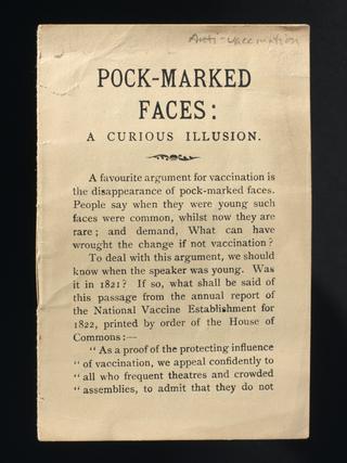
'Pock-marked faces: A curious illusion', anti-vaccination leaflet
Technical script for 'Our World' television broadcast
Report on a fact-finding trip leading to the development of the LEO computer, 1947
Writers' original script for 'Our World' TV broadcast